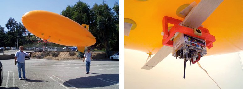
The TAOSF aerostat observation platform. The photo on the left shows the aerostat, which is an unmanned, lighter-than-air (LTA) unpowered blimp on a tether. Helium is used for buoyancy. The gimballed TAOSF observation platform avionics package is shown on the right. It includes a GPS, a barometric altimeter, a magnetic compass, a serial wireless data link, a wide-angle color camera, and a video transmitter.
Earth science research must bridge the gap between the atmosphere and the ocean to foster understanding of Earths climate and ecology. Typical ocean sensing is done with satellites or insitu buoys and research ships which are slow to reposition. Cloud cover inhibits study of localized transient phenomena such as a Harmful Algal Bloom (HAB).
A fleet of extended-deployment surface autonomous vehicles will enable in-situ study of surface and sub-surface characteristics of HABs, coastal pollutants, oil spills, and hurricane factors. To enhance the value of these assets, we propose a telesupervision architecture that supports adaptive reconfiguration based on environmental sensor inputs ("smart" sensing), increasing datagathering effectiveness and science return while reducing demands on scientists for tasking, control, and monitoring.
We will autonomously reposition smart sensors for HAB study (initially simulated with rhodamine dye) by networking a fleet of NOAA surface autonomous vehicles. In-situ measurements will intelligently modify the search for areas of high concentration. Inference Grid techniques will support sensor fusion and analysis. Telesupervision will support sliding autonomy from high-level mission tasking, through vehicle and data monitoring, to teleoperation when direct human interaction is appropriate.
Telesupervised surface autonomous vehicles are crucial to the sensor web for Earth science. We will integrate technologies ranging from TRL 4 into a complete system and reach TRL 6 within two years. In the third year, we will advance the system to TRL 7. This system is broadly applicable to ecological forecasting, water management, carbon management, disaster management, coastal management, homeland security, and planetary exploration.
JPL has a co-investigation role for this work, which is led by
John Dolan of Carnegie Mellon University. Partners also include teams from NASA Goddard and NASA Wallops.