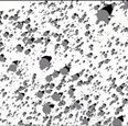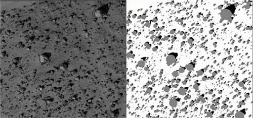
Rocks detected in orbital imagery using shadow analysis. Left shows the original image, and right shows the estimated size and position of each rock. Comparison with spacecraft capabilities determines if rock sizes and distribution presents a hazard for landing.
Recent imaging attempts by MRO HiRISE Camera in support to Phoenix mission landing site selection activities revealed unusually high concentration of rocks near the North Pole of Mars, where the terrain was previously thought to be benign for spacecraft landing. Thus far, 46 HiRISE images have been collected over three potential landing sites, but less than 0.01% have been analyzed, due to a manual process which is extremely slow and unreliable.
We will develop an autonomous hazard rock detection and statistics system, which can process a very large volume of orbital imagery in a very short period of time. The core algorithm of this system will be based on the existing EDL rock detection algorithm developed under MTP Advanced EDL program. With a few modifications, we will be able to deliver this system quickly, meeting the critically immediate needs of the Phoenix mission. In the long term, this system will provide a capability for other landed missions such as MSL and Mars Sample Return.