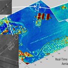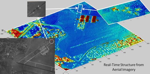
An example of JPL data processing handled in real-time for Angel Fire.
Angel Fire is an aerial platform designed to provide persistent, high resolution imagery of a wide area. JPL has provided image processing software and algorithms to produce real time geo-rectified images of the observation area with low latency. The JPL effort includes: automated (in air) calibration of the sensors; pixel level stitching of the camera imagery; stabilization; mapping and geo-registration; projection of the imagery on a terrain map; and generation of scene structure from the images.
The software produced for Angel Fire by JPL work in a multi-processor environment that resides on the aerial platform. The software and Angel Fire is currently operational and is used by image analysts to monitor an area for real time situational awareness.
This work is funded by the
Air Force Research Laboratory (AFRL).